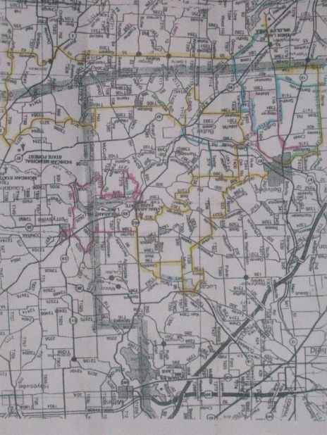
 There rides amongst us a small, super elite group of cyclists. Few know of this shadowy group. Rather than ride the COP roving rides with us shelps on Saturdays, this "special forces" group rides the routes on Sundays. I have known of their existence for a long time but like images of UFOs, presenting proof is challenging. This elite group of cyclists have a special route on which they train under the code name "FRANK". They use this route to prepare them for super rides such as"Mountain Mama", "Mountains of Misery", "Blood, Sweat & Gears", "Tour de France", "Giro de Italia", etc.... Long I have sought a map of this route. I have my informants and stooges throughout central Ohio but no one has ever provided me a copy of this super climbing & training route......until.....tonight!!!!!!!!!!!!!!! In order to protect the innocent, I will change the name of the hero who, at long last and finally, gave me a freakin copy, "Ted" who risks alienation from the group if not a bullet in the back of the head, bravely gave me a copy which I have posted above. This route is around 100 miles and well over 9500' of climbing. Do you realize how hard it is to come up with a century ride that actually has 10,000' of climbing, without doing endless repeats up Chickencoop????? Nearly impossible but now, I have that route. I strongly believe in "open content" so rather then selfishly keep for my own and use the Frank route to turn me into a super cyclist, I now share with you all. Frankly, I do not recognize any of the villages and towns so I'm not even sure this is in Ohio but further research on my part will reveal additional details, which I will share with you all. UPDATE!!! I have received a couple of messages from members of the super secret cycling group regarding the publishing of their training route. I may have to go into hiding after Imam Dubois issued a fatwa against me but one member sent me this chilling warning: Like any good treasure map, this one might kill you. Mark, do not ride the blue line clockwise, it contains a hill that should only be climbed. The bottom is a one lane road, any car on it with a bicycle descending = crash. Cars do have the good sense to drive under 30 mph on it (cyclists do not) and when you're climbing you can get to an edge before impact with the descending car. Never mind the hidden stop sign at the bottom. There is no fence and plenty of corn for your off road adventure. Yellow line is about 75 miles.
5 Comments
Ryan
7/27/2010 11:43:59 pm
It's an upside-down map of the area west of Loudonville.
Reply
The Dirty Frank
7/27/2010 11:57:40 pm
http://connect.garmin.com/activity/41845086
Reply
In the Know
7/28/2010 12:30:44 am
Ryan, This group is well aware of riding in Hocking Hills but chose the area on the map because the hills have the perfect length, perfect gratient, etc.. to properly prepare for the Grand Tours. Your little romp around Hocking Hills is vastly inferior for all of the above reasons.
Reply
Jeremy
7/28/2010 01:07:22 am
Can we expect some copies of this map Mark? It would be appreciated.
Reply
Ryan
7/28/2010 01:58:53 am
Mark, you make it sound as if I've never been to the Loudonville area. I have seen the snow-capped peaks with my very own eyes. They don't call that area the "Swiss Alps of Ohio" for nothing.
Reply
Leave a Reply. |
Categories
All
Archives
November 2023
|
