|
I've received some nice comments about the Canyon report and so, in the next week or so, I'll post much shorter reports of other Canyon hikes. Including almost stepping on a rattlesnake but was fortunate that it had a half swallewed mouse in its mouth, a Canyon Pink rattlesnake I tried to touch, a Diamondback that came too close while I was sitting on a rock, reading a book and other mishaps I have been fortunate to survive.
0 Comments
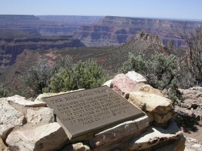 The start of the Bill Hall trail, so named after a former park ranger and an exhilerating route into the wild. Cameras don't come close to capturing the beauty. This is a long report. It could be a lot longer too because I left out quite a bit but I hope you enjoy it. In 2003, I talked a friend and fellow cyclist, Greg Dubois, into joining me for a backpacking adventure off the North Rim of the Grand Canyon. I had a few of these trips under my belt, including the exact trip Greg and I had planned, as well as several day hikes to the Colorado River and back off the South Rim so I thought I had all the bugs worked out. We were lucky to come out alive. We flew into Vegas, rented a car and took the scenic drive to the North Rim, checking into the Kaibab Lodge. We packed our back packs and bought everything that we were unable to bring on the plane, including fuel for the stove and lots of water. Our plan was to leave 2 quarts in the car so it would be there when we got out, each carry a gallon to a cache point 3.4 miles from the Bill Hall trail head (so it would be there on our way out) and then have 4 quarts with us for the long walk to the river. We turned in early because we wanted to be at the trail head at 5:30am, to allow plenty of hiking time. On my previous trip to this trail head, I had spent the night in the car but that was not comfortable and it gets very cold during the night, even in late May, at the Rim's elevation. The drive out to the Bill Hall trail head is 31 miles, along forest service roads through thick forest and the pace is slow. However, we arrived on time, assembled everything and shoved off. Our intent was to spend two nights in the Canyon. The temperature that morning was in the mid 40's which is kind of warm for late May but the day time high in the inner Canyon was expected to be 105. The trail rises moderately at first with the elevation soon causing heavy breathing but then it drops abruptly though broken ledges of the Kaibab limestone.The first part is very steep and rocky, requiring great caution (there ain't any guardrails around here). We hiked in the shade for a long time but the temperature was rising quickly as we went deeper into the Canyon and the sun rose higher overhead (did you know the temperature difference between the rim and bottom is 25-30 degrees?). Eventually the trail moderates and normal walking is a welcome relief. We came across a guy who was hiking out and who had one of the soles of his hiking boots fall off. He had some tape and had been able to partially tape it back but it was still kind of funny watching him trudge along with the rear of the sole flopping open. Let me tell ya, losing the sole of your hiking boot in that environment is not good......and yes,8 miles into the trip, my right boot sole came off. I could not believe it! These Technica boots had been with me for many miles of backpacking in the Canyon. Fortunately, Greg had some string and some medical tape and I lashed the sole back to the boot. We discussed turning back but I was determined to press on. About a mile later, the sole of my left boot came off too..incredible but true. More string and tape around the sole and boot body kept the parts together but it was like wearing heavy flip-flops with the heel flapping open every time I lifted my foot and the toe flapping open to collect trail debris that would lodge between the middle of my foot and the sole. It required frequent stops to clean out the debris and somewhere, I lost my sunglasses. Our first major destination was Thunder River, so named because it gushes from a limestone cavern under hydraulic pressure and is also known as the world's shortest river as it runs 1/4 mile before it dumps into Tapeats Creek which eventually reaches the Colorado River. Where the water gushes from the cavern there is an area that receives constant mist and it is an oasis of greenery. Prior to our arrival we had traversed the Esplanade, a broad, flatish layer of rock that is like walking on the moon, dropped through the red rock to Surprise Valley, formed when a large area slumped into itself. At the rim of Surprise Valley you can first hear and then see the incongruous view of Thunder River in the middle of a desert environment. The trail drops rapidly with Tapeats Creek roaring by, having received Thunder River's contribution. The environment is absolutely spectacular, awe inspiring, dangerous and the panoramic views, wow. At times the exposed trail takes one well above the creek before dropping again. This is a wild section with great hiking. We finally reached Lower Tapeats campsite on the Colorado River at mile 10.4, but oddly there was no one there (this is a common stopover for rafting parties) and so we decided, since it was still kind of early, to hike the 4.1 miles along the river route over to Deer Creek Narrows. Big mistake. The Canyon is a very inhospitable place and when you've been dragging your boots through the dirt and sand and adding weight with every step...we should have stopped. Now, in the inner Canyon it rarely rains. It rains plenty at the rim but evaporates before reaching the inner Canyon, a one mile change in elevation. We headed west, parallel with the river on a trail that rises and falls, spectacularly so at a point where the trail rises 800' in .7 of a mile. The route forces slow going with scrambling over house-size boulders, down climbing rocky outcroppings and even walking along a sandy shore. At the point where the trail turns abruptly up that 800' slope, I instead followed a bighorn sheep path and kept going. Greg had been behind me and after not seeing him, I waited and then began to shout his name. I honestly thought he had died, how else to explain his absence? I wondered how I would tell his wife and began walking back, still yelling his name. Suddenly, he called me and I looked up and realized the rookie Canyon hiker had followed the trail and I had not. Gesh. At the top of the rise, one is greeted with awesome views both up and down river but we were distracted by dark, broiling clouds and a howling wind. Soon it began to rain, a nice, steady, soaking rain that felt good considering the temperature was around 100. There was plenty of lightning and thunder too, What a scene as we trudged on. At one point, I distinctly remember putting my foot forward and at the same time, a large snake slithered between my legs while another slithered ahead of me. Normally this would produce a scream and racing heart but I was so tired I didn't care. I've had plenty of encounters with the Western Diamondback and the unique Pink Rattlesnake in the Canyon and it scares the bejeebers out of me but I don't know what kind of snake they were. You see, it was dark and at night, the snakes come out. We were fortunate in that most of the trails in the areas designated "wild" and "remote" are marked by cairns, not a recognizable trail. Cairns are also called "Ducks", so named because in nature, a rock perched on another is normal but 3 or more rocks perched on each other is not and so that is what marks many routes. They are called ducks because with the smallest rock on top and the largest on the bottom, the shape kind of looks like a duck. The famous river trail has an obvious foot path. We kept going into and out of side canyons, traversing scree slopes on narrow paths a couple hundred feet above the Colorado. Each side canyon looked like the last and I'm sure I drove Greg crazy with frequent pronouncements of, "This is the last one before we hit a rise that goes over a saddle and into the Narrows". We finally reached the base of a long rise that does lead over a saddle. I remember sitting on a rock, rain pouring and feeling fairly miserable and more tired then I have ever been. I dragged myself up the trail, down the side of the saddle and into Deer Creek Narrows. I was kind of delusional and wanted to just lie down but there is a permit process that requires stopping at a designated area so in pitch dark we stumbled around and eventually found our spot. We each set up a lightweight tent but because it never rains in the inner Canyon, nor had any been forecast, there was no protection from the rain. We laid there, rain dripping through the tents but did sleep or pass out. We had walked 16 miles over very rough terrain. The next morning we decided to hike out and forget spending another night and then I began filtering water from Deer Creek as we would need about 4-5 liters for the portion of the route that would lead us to our water cache. The PUR water filter, which had served me well broke but somehow I nursed it along, gaining the needed water. Greg started ahead of me while I filtered the water but once I started, I did not see him on the trail above. I shouted his name and he answered, from a spur trail that led to a dead end. In an act of bravery (snakes, scorpions, tarantulas), he bushwacked across a thicket of brush and reeds that stood over 9'. He finally emerged and we proceeded up the limestone face to Deer Spring, spewing from the face of the limestone.. We kept going up and eventually navigated a narrow scree path, that crosses slightly above the water, able to feel the rumble of the surging water beneath us and hearing the accompanying loud roar. One can be forgiven for leaning hard to the left as the view into a deep chasm taking in the surging water.is intimidating. After some serious climbing we reached Surprise Valley and then the Esplanade, where we missed a cairn and headed toward the wrong trailhead. After a mile I began to doubt the direction because we were walking out of sight of some views I remember from my previous trip. We circled back and found the right trail. We found our water cache and things were looking up. As if enough odd things had not occurred, we approached a scrub pine tree and in one of the forks there was a sealed 1 lb.summer sausage. Someone had left it for later retrieval and everyone honors the code of not raiding someone's cache. After 29 miles of hiking (both days) dragging flopping soles through the trail, we reached the rim, at 6:00pm. We both agreed it was the hardest thing we had ever done. Greg headed back to Columbus and the next day, I plunged back into the Canyon. I love that place. 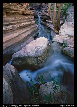 Close to the start of the Narrows. 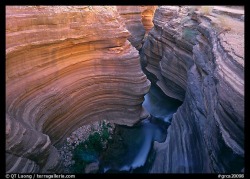 Deer Creek Narrows. The depth of the Narrows deepens as you get closer to the Colorado and then a falls ends the Narrows. Wild place.
|
